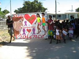
 Pormpuraaw State School is located in the Cairns and Cape District and services the Pormpuraaw community, which was known as the Edward River Mission until 1987. Geographically isolated on the west of the Cape York Peninsula, Pormpuraaw has a population of approximately 700, 650 of whom are indigenous Australians. The council operates a diversified enterprise operation, including a crocodile farm, pastoral and cattle property and river-based fish camps.
Two groups of Aboriginal people live in Pormpuraaw. The Thaayore are traditionally from the area to the south, including the Coleman river. The other group is made up of people traditionally from the area to the north, including the Edward and Holroyd rivers, and are generally known as Munkan people. Due to flooding, the community can be isolated during the wet season from mid- October until May. Travel to and from the community at this time is only possible by air services. Freight comes via air and barge transport. In the dry season roads are open to Cairns and Weipa, but four-wheel drive is advisable.
Cape York is seen by many as the 'last frontier' and is undergoing rapid change environmentally, socially, culturally and economically. It is the role of our school to provide an educational service to assist communities in these times of change.
Services available in Pormpuraaw are: